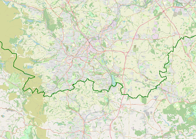
Paul French has kindly supplied the following map which shows the Yorkshire boundary as used by the YNU and is also valid for use in the Yorkshire Birding Lister's League. Please remember that for your bird to be deemed countable for inclusion in the Yorkshire Listers League both the bird AND the observer must be within the Yorkshire area.
The series of maps below, also kindly produced by Paul French, give a more detailed view of each sector.


THE YORKSHIRE BOUNDARY
ReplyDeleteCraig Thomas
Over the last fifteen years there has been resurgence in Yorkshire birding; partly as a result of competition engendered by the publication of birders’ county lists. However, a fundamental question remains; what constitutes Yorkshire? Following the modern-day political boundaries of North, South, East and West Yorkshire initially appears simple enough, but what of the area of former North Yorkshire now consumed into Cleveland?
Two contrasting approaches have been adopted by county recorders when defining their respective county.
Watsonian Vice-Counties In 1852 HC Watson wished to divide the British Isles into permanent units in order to record data from botanical surveys; he subsequently devised a system of vice-counties, each roughly of equal size. Most counties consist of only two such units, although Yorkshire is covered by VCs 61 to 65 due to its size. Most naturalists record their respective flora or fauna by Watsonian vice-counties, with the general exception of birders.
Socio-political boundaries Most birding county societies follow socio-political boundaries. The main advantage is that boundaries are clearly defined on virtually all maps (including road atlases) and even road signs alert to the start of the next county. This is clearly not the case for Watsonian Vice-counties! However, boundaries often change due to political process; the most recent changes occurring in 1974 and 1996. This results in ambiguities for county avifaunas, where a single record can enter one county list and then subsequent records at the same site enter a different county list!
It is clear that these ambiguities would cease to be a problem if recording areas were consistent and independent of political process; in other words by following the Watsonian vice-county system. This has been recognised by The National Biological Records Centre which follows the VC system. The Yorkshire Naturalists Union also follows the Watsonian Vice-County system and the Bird Report (which covers all species recorded in the county) reflects the VC-boundaries.
Neighbouring counties follow socio-political boundaries. For example, to the south Derbyshire adopts the post-1974 boundaries. However, anomalies exist in several areas; the boundary of South Yorkshire was extended beyond the VC 63 boundary in 1934 and 1968 to reflect the ‘retreat’ of Derbyshire. When producing the county avifauna, YNU considers records from this ‘extension’ in order to prevent such data being lost; this has particular importance for birders working Blacka Moor and Rother Valley Country Park. Similarly, an area west of Todmorden transferred to Yorkshire from Lancashire in 1889, but is still in VC 59. Since this area forms part of the Halifax recording area, records from here contribute to the Yorkshire avifauna. The YNU continues to publish records from South Cleveland, part of VC 62, but assessment of records from that area is by the Cleveland County Recorder and Teesmouth Bird Club.
VC maps are now more widely available on the internet, so it is not difficult to determine the boundaries. Ordnance Survey grid references for any site can be converted to VC at the HerbariaUnited website www.herbariaunited.org/gridrefVC/ and information on site grid references are easily obtained from the online Ordnance Survey “Get a Map” facility, or from the site directories on www.birdguides.com. YNU’s Ornithological Section intends to publish detailed VC maps for Yorkshire in future bird reports and on its website.
Craig Thomas, YNU Chairman.
Interesting article Craig. You may be interested to know that there was a small article in the Yorkshire Evening post tonight (p.17) about the Yorkshire Boundary Sign Project. It follows along similarly with your thoughts but it's aim is to restore the old ridings boundaries and signpost them. The project leader is Andy Strangeway and he has a blog. He said, on his blog,......over the past week there has been discussion regarding Yorkshire boundary signs south of the river Tees and durhan signs to the north. this sounds like good news for Yorkshire people and birders. I believe that bird recording boundaries should always be historical and not to change at the whim of politicians who will just change boundaries to suit themselves.
ReplyDeletePete Griffin, Leeds